

Beach Evolution
Factors influencing beach evolution and erosion
-
Nature of the mobile sediments between low and high tide limits.
-
Beach slope
-
Prevailing wind and waves-Longshore Drift
-
Alignment of the coast
-
Coastal Geology
-
Tidal stream
-
Human engineering intervention
These considered elements of beach erosion are outlined below. Further information is contained within the study of the beach that protects Eastbourne Bandstand.
Beach Sediments
Beach Sediments
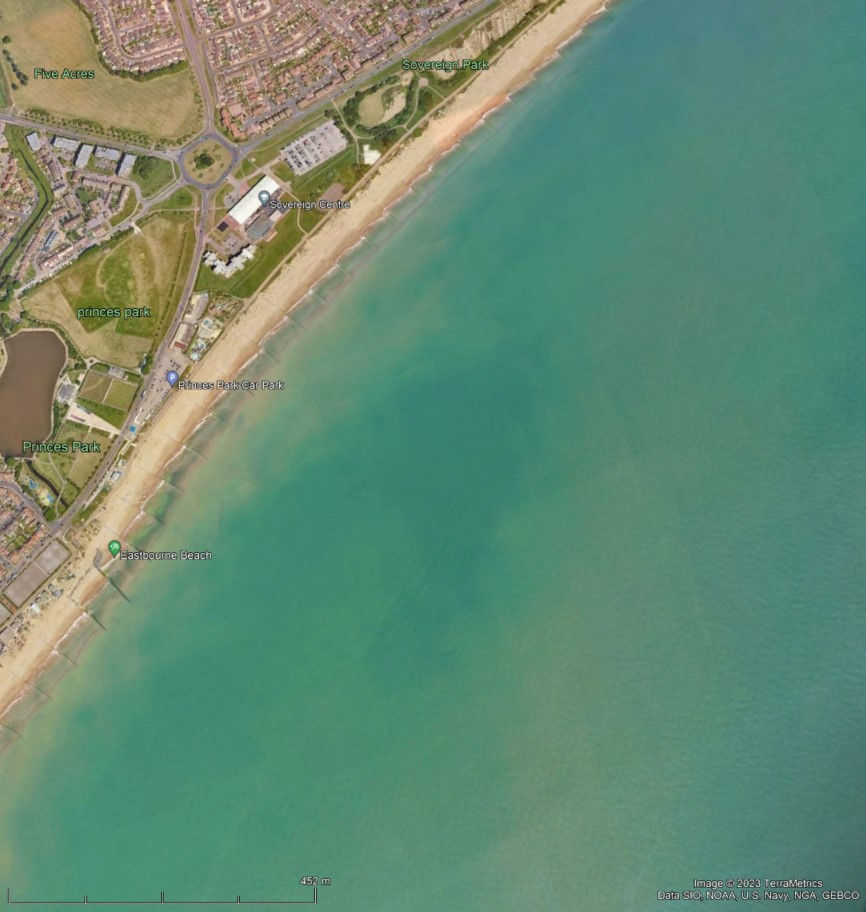
The beaches along the coast between Beachy Head and Cooden are a chaotic mix of sand, shingle and cobbles. This deposit can be considered anthropogenic and it does not conform to standard beach erosion theories. It is composed predominantly of imported sand and small round pebbles, orange brown in colour, a mix entirely unsuitable to resist storm waves. These contrast with the large grey cobbles and shingle that is derived from erosion of the Seven Sisters cliff line. A relatively small volume of these is required to absorb incident wave energy without significant beach movement.
· Beach sediments are composed of locally derived grey cobbles and shingle, and imported rounded shingle orange-brown in colour. At present the predominant component is the imported shingle and variable, but influential content of sand, reported to be up to 20%. The former are lost mainly by drifting north eastwards along the HW water mark, and the ballast generally slips down the beach.
· The locally derived grey cobbles and shingle arrives in erratic pulses, some years following a major cliff failure. The chalk and flint scree deposited in 1999 close to Eastbourne lighthouse has been worked by wave action. The resultant grey flint cobbles have been pushed along the cliff base by storm wave and are now stabilising 12 beaches east of Holywell spring rock armour. This represents a lag of 25 years between fall and grey cobbles reaching the Holywell beaches. The distance between the Lighthouse and Holywell spring is 2.9km
· Historic photographs of Eastbourne beaches illustrate that the beach deposits have waxed and waned, and consisted predominantly of large clasts. There must have been some program of recharging when cliff derived drift deposits were lacking. Until the second world war a thriving maritime community existed, building and operating a wide range of wooden boats. Archives are currently been searched to find any evidence that these boats were also used to bring deposits from beaches along the cliff line, as and when required.


Beach Slope
The slope of the beach governs the rate of draw-down losses. In the image from the beaches at Pevensey Bay facing east towards Normans Bay the hard substrate is made up of a chaotic mix of Sands, Shingle and Cobbles, The small rounded shingle will eventually find its way down slope and be assimilated within the low tide zone sands The slopes vary along the coastline and are dependent on the nature of the sediment, underlying geology and relationship between wave direction and local coastal alignment.

Longshore Drift-Prevailing Maritime Conditions
Longshore drift is a geomorphological process driven by prevailing maritime conditions. The coastline between Beachy Head and Cooden face the prevailing waves at different angles as the alignment of the coast changes randomly between 30 and 70 degrees.
The prevailing wave trains also change direction in relation to changes in nearshore seabed topography and headlands. The wave energy vectors constantly move the shingle and sand deposits, and erode outcrops such as the Seven Sisters cliff line.
These forces work over many timescales ranging from several seconds to decades and millennia. They exist in states of quasi-equilibrium and also evolve in response to changes in maritime forces and human exploitation.
The current mechanically derived chaotic sediment remain far from an equilibrium state and more is being lost to the low tide zone than along the coast.
Alignment of the Coast and Nearshore Bathymetry
The alignment of the coastal margin is governed by three factors; outcropping geology, sediments distribution and human engineering, often in combination.
Along the entire length of the subject coastline; 14km from Beachy Head to Cooden the coastline randomly changes alignment between 030 to 070 degrees.
The direction of the prevailing southwesterly waves is altered by changes in seabed depth. Rock outcrops and sand banks northeast of Beachy Head induce the wave train to turn towards the shallower section.

Coastal Geology
Eastbourne is built on Chalk Upper Cretaceous Limestone, Gault, and Upper Greensands. These units outcrop along the coastal margin between Beachy Head and Redoubt where they dip down below seabed level and under Pevensey Levels. These are known as sedimentary rocks and were deposited in separate environments much different to those of today. After their formation they were uplifted into a dome shape by the same forces responsible for the formation of the Alps. Millions of years of natural erosion scoured out the center of the dome leaving chalk ridges that outcrops as cliffs along Hastings and Eastbourne. Pevensey Levels is enclosed by these chalk ridges that extend north-west.


Tidal Stream
The tidal stream has a small impact on shingle erosion. The fines; sand, silt and mud are mixed into the water column during rough weather. The suspended loads are then carried along with the tide. During slack water these small particles are deposited on the inter-tidal zone seafloor. The mobile sand deposit formed into various bedrooms that change the topography of the seabed which alters the nature of the waves breaking onto the beach, and consequently the erosion pattern.
Plumes of sands and silts are moving northeast close to the beach and appear to arc back further offshore to the southwest.

Human Intervention
How the Neolithic, Bronze Age settlers and Iron Age Celts managed the coastal margin remains the subject of debate. The Romans most likely built over an existing Iron Age fort at the location of Pevensey Castle and there is evidence for a small Roman harbour at the Devonshire Park tennis courts. An examination of a topographic map reveals that a narrow inlet from the beach east of the Wish Tower would allow access by water down Carlise Road. Their engineering skills were likely used to build wooden revetments as seen along the Thames.
The first wooden groynes were installed 1300 years after the Romans departed and beaches enclosed recharged after natural losses.
